
Surveying machines are vital in construction and land development. They ensure precise measurements and accurate data collection.
These machines have evolved significantly over the years. From traditional tools to advanced digital devices, the options are vast.
Surveyors and engineers rely on these tools for various projects. Each type of surveying machine offers unique features and benefits.
Understanding these differences is crucial for making informed decisions. The right equipment can enhance efficiency and accuracy.
Modern surveying technology includes LiDAR, drones, and 3D laser scanners. These innovations are transforming the industry.
Choosing the right survey gear depends on project needs and budget. It’s essential to compare features and performance.
Surveying equipment manufacturers continue to innovate. They focus on user-friendly designs and advanced technology.
This guide will explore different types of surveying machines. It will help you navigate the options available today.
The Evolution of Surveying Machines: From Traditional to Digital
Surveying equipment has undergone a dramatic transformation. Traditional instruments laid the groundwork for modern devices. Precision in measurements was always the primary goal.
Early tools like compasses and chains were simple yet effective. They served basic survey functions but required manual effort. Progress soon introduced theodolites and levels, advancing accuracy.
Digital technology revolutionized surveying. Electronic total stations brought automation and precision. They streamlined data collection and reduced human error.
The rise of GPS and GNSS systems marked a new era. These tools offer real-time location data and enhanced accuracy. They are indispensable for modern land surveying projects.
Today’s devices integrate cutting-edge technology:
- LiDAR systems
- 3D laser scanners
- Drones with advanced imaging
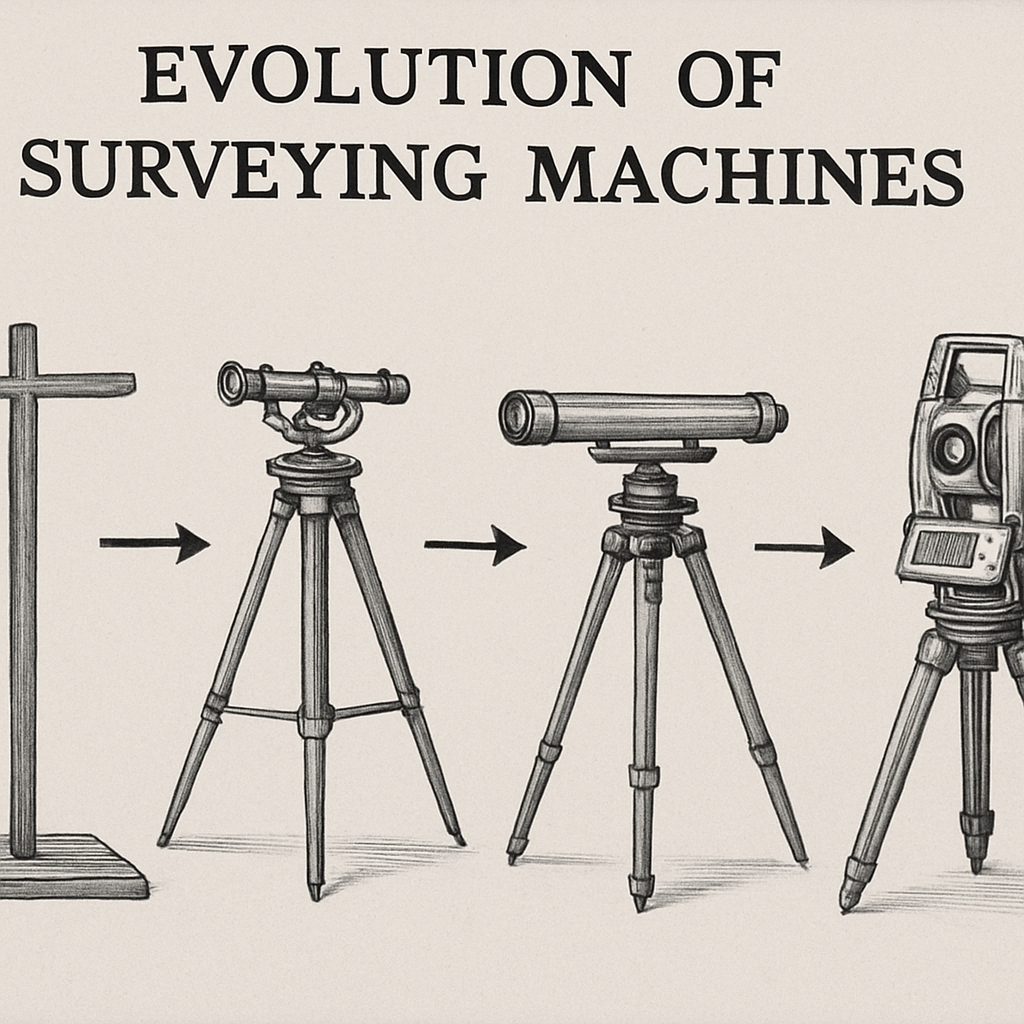
Each development improved surveying processes. Enhanced tools enable efficient data gathering and detailed analysis. The move from traditional to digital represents a landmark in surveying history.
Core Types of Surveying Machines and Their Functions
Surveying relies on a range of machines, each serving specific purposes. These machines enhance the precision of land measurements. Understanding their functions helps in selecting the right tools.
Surveying machines include:
- Theodolites for angular measurements
- Levels for height differences
- Total stations for distance and angle
- GPS/GNSS devices for real-time data
- 3D laser scanners for detailed imaging
Each category of these machines offers unique capabilities. Surveyors need tools that match their project needs. Advanced machines integrate multiple functions for efficiency.
Theodolites and Transits
Theodolites are essential for measuring angles in surveying. They have been a staple in geodetic equipment for years. These tools provide precise angular readings for land plots.
Transits, similar to theodolites, are also used for angle measurements. They feature a telescope mounted on a tripod. They help in determining both horizontal and vertical angles.
Modern theodolites have electronic versions with digital readings. These advancements reduce manual calculation errors. They are vital for boundary surveys and topographic mapping.
- Key Features:
- High precision optics
- Digital readouts
- Easy portability
Theodolites are among the oldest yet reliable surveyor instruments. Their durability and accuracy are unmatched. Choosing the right model depends on project specific needs.
Levels: Auto, Digital, and Laser
Leveling devices are crucial for measuring height differences. Auto levels use an automatic compensator to level a survey line. They offer easy operation for routine fieldwork.
Digital levels enhance precision with electronic data collection. They improve speed and reduce human errors. The data can be easily integrated into digital tools.
Laser levels project a beam, providing a visible reference line. They ensure accuracy in construction and landscape surveys. These are especially handy for setting elevations over large areas.
- Variants:
- Auto level
- Digital level
- Laser level
by Leslie Lopez Holder (https://unsplash.com/@leslielopezholder)
Levels are indispensable survey tools for building projects. They simplify the process of ensuring level construction over varied terrain. Selecting the right level depends on specific task requirements.
Total Stations: Manual, Electronic, and Robotic
Total stations combine optical instruments and distance meters. They measure angles and distances simultaneously, enhancing efficiency. These are indispensable in modern survey measurement tasks.
Manual total stations require manual adjustments for measurements. They are cost-effective but need skilled operators. Electronic versions use digital displays, increasing reading accuracy.
Robotic total stations offer automation. They use motors and remote controls to capture data autonomously. Their precision reduces time spent on-site, increasing productivity.
- Characteristics:
- Measures angles and distances
- Automatically captures data
- Enhances workflow efficiency
Robotic total stations are aligned with construction surveying 2025 trends. They enable complex surveys with minimal human intervention. The choice largely depends on project scope and budgetary constraints.
GNSS and GPS Survey Devices
GNSS and GPS devices revolutionize location data collection. They offer precise global positioning crucial for large-scale surveys. These systems are widely used in construction, agriculture, and mining.
GNSS provides consistent positioning data from satellite constellations. It ensures accuracy across different regional systems. GPS focuses on U.S. satellites, offering robust navigation solutions.
Integration with total stations enhances data collection. Surveyors receive instant feedback, expediting the survey process. These devices are reliable for field surveys requiring geodetic precision.
- Benefits:
- Real-time positioning
- Compatibility with other tools
- High accuracy
These devices are indispensable in topographic surveys. They offer cost-effective solutions for field data collection. Selecting a GNSS or GPS device hinges on coverage and specific requirements.
3D Laser Scanners and LiDAR Surveying
3D laser scanners offer high-resolution spatial data. These survey measurement tools capture precise details of structures. They are essential for as-built documentation and heritage site preservation.
LiDAR technology takes scanning further. It uses laser light to measure ranges, covering vast areas quickly. LiDAR surveys are popular in building documentation technology.
These tools are used in 3D modeling and urban planning. They streamline the transition from physical to digital models. Scan to BIM is a critical application in construction technology.
- Applications:
- Detailed area mapping
- Building Information Modeling (BIM)
- Terrain and environmental surveys
 by AFINIS Group ® – AFINIS GASKET® Production (https://unsplash.com/@afinisgroup)
LiDAR and laser scanning are crucial for reality capture tools. They generate data-rich models for virtual analysis. The choice depends on detail level and project goals.
Drones and UAVs for Surveying
Drones enhance surveying with aerial perspectives. They capture images and data unreachable by traditional means. These flying survey devices are invaluable for large and complex sites.
UAVs collect data quickly, covering more ground in less time. Their cameras and sensors offer real-time imagery for analysis. Drone surveys are increasingly used in property surveys and land mapping.
Advanced drones integrate LiDAR for even greater accuracy. They provide 3D models and digital elevations. Using drones reduces fieldwork time, increasing project efficiency.
- Advantages:
- Captures data from hard-to-reach areas
- High-resolution imaging
- Reduces labor costs
Drone surveying construction techniques lead the industry. They allow for efficient data gathering with minimal environmental impact. Selecting the right UAV depends on terrain and survey objectives.
Specialized Surveying Tools and Accessories
Specialized tools boost the capabilities of primary surveying machines. These accessories enhance precision, efficiency, and user safety. Whether you’re aligning structures or mapping vast tracts, accessories make a difference.
Accessories cover a wide array of tasks in civil engineering and geodetic projects. They ensure the main tools operate at their best. With the right accessories, surveyors can tackle unique challenges easily.
- Accessories include:
- Prism systems for total stations
- Reflective targets for improved accuracy
- Tribrachs for stable equipment mounting
- Survey poles and rods for line site applications
Choosing the right accessories maximizes a surveying machine’s potential. They not only improve accuracy but also extend the lifespan of devices. Selecting high-quality accessories is essential for optimal surveying outcomes.
Advanced Surveying Equipment: Reality Capture, Scan to BIM, and As-Built Tech
Advancements in technology have revolutionized surveying techniques. Reality capture tools are at the forefront, providing unparalleled detail. These tools create precise digital replicas of the physical world.
Scan to BIM transforms raw survey data into building information models. This process aids architects and engineers in visualizing projects before construction. Such technology improves planning and reduces costly changes.
As-built technologies ensure completed structures match original designs. Surveyors use these tools to verify construction precision. Any discrepancies are promptly identified, ensuring quality control.
Key components in advanced surveying include:
- Reality capture tools for detailed imaging
- Scan to BIM for efficient model integration
- As-built tech to maintain construction accuracy
This technology’s impact is transformative, streamlining complex projects. These innovations enhance accuracy and efficiency in various industries. Embracing advanced surveying equipment is crucial for modern infrastructure development.
Comparing Surveying Machines: Key Features and Performance Metrics
Surveying machines vary greatly in features and performance. Each type of device offers unique advantages based on needs. Understanding these features is vital for choosing the right tool.
Precision is a critical metric in surveying equipment. The accuracy of measurements can significantly affect project outcomes. Machines with high precision reduce errors and improve project efficiency.
Durability and usability also matter. Surveying often occurs in harsh environments, necessitating robust tools. User-friendly interfaces enhance productivity and reduce training time.
Key features and metrics include:
- Measurement accuracy
- Device durability
- User interface simplicity
- Data processing capabilities
- Portability and weight
These elements guide the selection of appropriate equipment. Choosing wisely impacts project success, minimizing delays and costs. Informed decisions optimize resources and improve project delivery.
Choosing the Right Surveying Machine for Your Project
Selecting the ideal surveying machine is crucial for achieving project goals. The project scope and environment heavily influence this decision. Each type of surveying device offers distinct capabilities suited to different tasks.
Consider the survey purpose and location. For large-scale land surveys, GNSS devices or drones may be optimal. For detailed architectural surveys, 3D laser scanners provide precise data.
Budget and technological needs should guide your choice. Balancing cost with necessary features ensures efficient investment. Advanced technology often yields better efficiency, saving time and labor costs.
Factors to consider:
- Project size and complexity
- Desired accuracy levels
- Environmental conditions
- Budget constraints
- Technological adaptability
Selecting the right equipment enhances project outcomes, ensuring smooth execution. Proper evaluation of needs leads to informed choices, tailored solutions, and successful results.
Surveying Equipment Manufacturers and Market Trends
Surveying equipment manufacturers are adapting rapidly to the demands of modern surveying. New technologies are transforming the landscape. Companies are focusing on producing more user-friendly and durable devices.
The market trends highlight a growing demand for integration and automation. Digital survey equipment now links seamlessly with software solutions. Manufacturers prioritize innovation, responding to trends such as AI and cloud-based processing.
Current market trends include:
- Increased automation and AI integration
- Development of portable and lightweight equipment
- Enhanced data processing and cloud connectivity
- Focus on user-friendly designs
These trends indicate a shift towards efficiency and technological advancement. As the market evolves, surveying devices continue to become more sophisticated and capable.
Survey Equipment Pricing: What to Expect in 2025
By 2025, the pricing of survey equipment is anticipated to vary widely due to technological advancements. As features like AI and automation become standard, prices might increase for high-tech devices.
However, more affordable options will likely emerge with simplified features. This caters to smaller firms and independent surveyors. Cost factors will include:
- Level of automation
- Integration capabilities
- Durability and portability
- Brand reputation
Budget and project size will influence equipment choice. Despite some increases, competitive pricing should keep quality gear accessible. This ensures a broad range of professionals can benefit from cutting-edge surveying equipment.
The Future of Surveying Machines: Automation, AI, and Digital Integration
Surveying is entering an exciting phase of innovation. Automation and AI are paving the way for more efficient workflows. These technologies promise to enhance accuracy and reduce human error significantly.
Digital integration is also becoming key in creating smarter surveying systems. These systems offer seamless data collection and analysis. Looking ahead, expect developments like:
- Autonomous surveying vehicles
- AI-driven data processing
- Enhanced IoT connectivity
These advancements will lead to better project outcomes and safer job sites. Surveyors will benefit from quicker, more accurate measurements, transforming how data drives decisions.
 by Shojol Islam (https://unsplash.com/@shojolislam)
Conclusion: Making Informed Choices in Survey Gear
Selecting the right surveying gear is crucial for every project. Understanding the features and capabilities of each machine helps guide decisions. This knowledge ensures the tools match specific needs and budget constraints.
As technology advances, staying informed about new developments is essential. Modern surveying instruments offer better accuracy and efficiency. Choose wisely to guarantee that these tools effectively meet today’s surveying challenges and tomorrow’s innovations.